
Farin Doutchi Fm
Type Locality and Naming
Mount Farin Doutchi near Ibohamane. Group: Majias Gr
References: Kogbe, 1973; Boudouresque et al., 1982; Hanon, 1990; Dikouma, 1990; Rat et al., 1991; Zaborski & Morris, 1999 ; Kané & Michaut, 2007; Michaut, 2007, 2012, 2013a, 2013b, 2015, 2017a, 2017b, 2018a, 2018b, 2018c, 2019a, 2019b, 2021; Moumouni et al., 2019; Laouali-Idi et al., 2021.
Synonym: Mosasaurus Shales; “Terme 2” of Greigert (1966); “Calcaires à Libycoceras” (Boudouresque et al., 1982). Equivalent(s): Dukamaje Fm in the Sokoto sector of Nigeria, or Mosasaurus Shale Fm
Lithology and Thickness
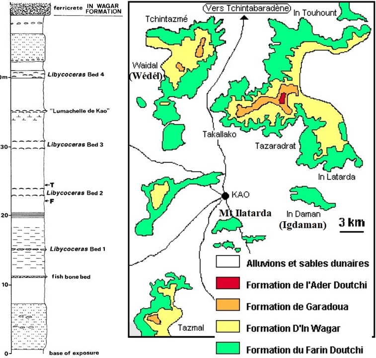
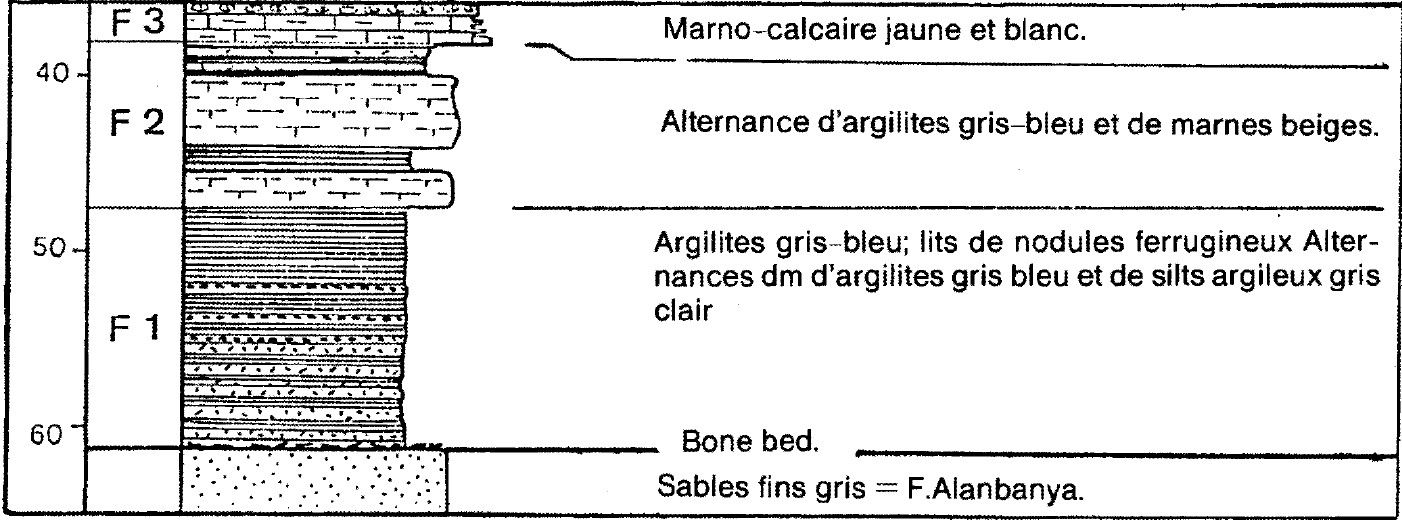
The Farin Doutchi Fm comprises the peak transgressive deposits of the first transgression with Libycoceras (transgression T3; Fig. 5-17). It consists mainly of light to dark grey clays, mudstones, shales and silty shales. A predominantly shaly Formation comprising several levels of marl and marly limestone. Often abundant gypsum crystallizations spread at the surface; phosphate nodule beds; alignments of ocher clay concretions and locally septarias; bone beds, lumachelles. The formation is subdivided into 3 Members, from top to bottom (Fig. 7-59):
- F3: Mustard yellow and white marly limestones: alternation of centimetric beds (1 to 5 cm thick) of white, pale yellow, micritic, generally clayey limestones and khaki or mustard yellow marls or argillites. Locally, centimetric beds of lumachelle at the base. In various points of Ader Doutchi (lower valley of Majya, northern border of the Ader at In Safari), this Member is associated with ferruginous oolites in lenticular beds up to 2 m thick; these concentrations of ooliths can be found both at the top and the base of the Member; they often contain, near the contact with the marly limestone, a fauna composed of the same species.
- F2: Alternation of metric beds of blue-gray, gray-green argillites or argilo-siltites and yellow marls; generally, well-marked foliation resulting in platelets.
- F1: Blue-gray, gray-green clays and argillites; centimeter to decimeter beds of brick-red, rust-brown ferruginized silts, often in the form of an alignment of rounded concretions; centimetric to decimetric beds of white or light gray silts more frequent towards the base; locally (Arzerori, Sanou): alignments of septarias. Concretions of light yellow pisolithic limestone and light gray clay balls (up to 2 m in diameter) with a lining of bright yellow calcite. At the base: one or more bone beds of centimetric thickness: phosphate and ferruginous encrustation of vertebrae fragments.
Thickness is 50 m around Kao. It is 27 m at Mont Farin Doutchi, decreasing quite rapidly to the south of the Keita valley: from the left bank of this valley to the border with Nigeria, it varies between 20 and 25 m.
[Figure 1. Generalized lithostratigraphic section of the Farin Doutchi Fm and basal part of the In Wagar Fm exposed around Kao, showing horizons with Libycoceras (Source: Zaborski & Morris, 1999). Colored map from Michaut, 2007. ]
[Figure 2. Generalized lithostratigraphic section of the Farin Doutchi Fm on Mount Farin Doutchi (Source: Hanon, 1990).]
Relationships and Distribution
Lower contact
Underlying unit is the Alanbanya Fm. The lower limit of the Farin Doutchi Fm corresponds to the disappearance of the sandy facies of the upper portion of the Alanbanya Fm; the contact is clear and generally marked by a bone bed.
Upper contact
Overlying unit is the In Wagar Fm
Regional extent
GeoJSON
Fossils
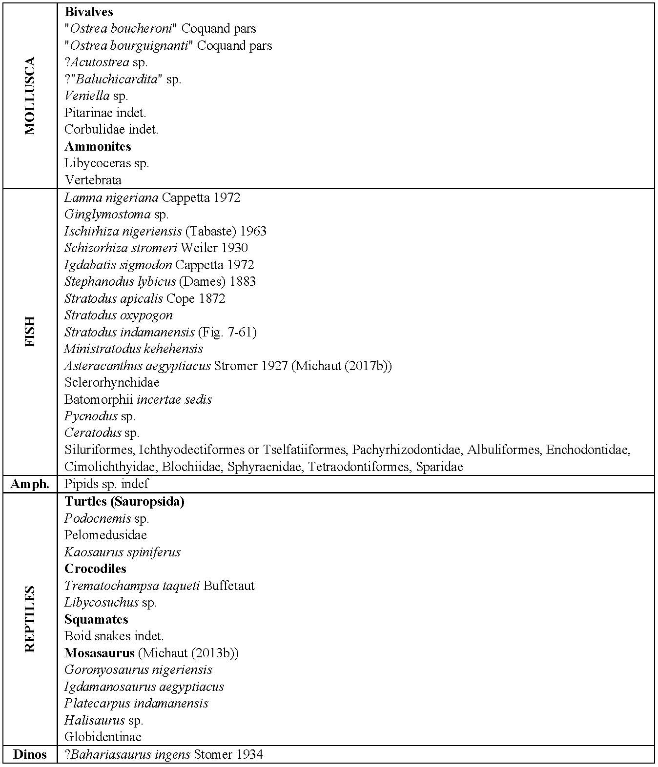
See Fig. 3. Remains of fish [holostean (Phacodus), teleosteans (Encodus), selacians/sharks (Corax, Notidanids, Lamnids, Scapanorynchus sp., Rajiformes cf. Rhombodus, Stephanodus sp. – Fig. 4)], Sauropsida (turtles, Kaosaurus spiniferus), mosasaurs, crocodylomorph (Dyrosaurus) and rarer dinosaur fragments. Invertebrate macrofossils are almost entirely limited to five horizons, ammonites (Libycoceras) occurring in four; beds 1 to 4 (Fig. 1; Fig. 2). Laffiteina (foraminifera), Brachycythere (ostracod), Veniella auressensis (Coquand), Pycnodonte (Pycnodonte) flicki (Pervinquiere), Glyptoactis (Baluchicardia) cf. ameliae (Pervinquiere), Modiolus sp. (all bivalves), more proximal lagoonal deposits (bone beds), and paludal deposits (grey shales rich in organic matter and pollenospores). In all cases, it is associated with a benthonic fauna of very low diversity.
[Figure 3. Faunal list from the Farin Doutchi Fm at Kehehe and Mont Igdaman (Source: Modified from Moody et al., 1991). The list is not exhaustive.]
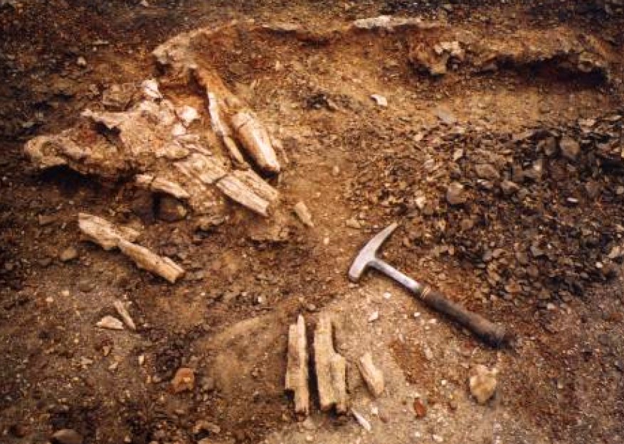
[Figure 4. Stratodus indamanensis (fish) discovered in 1999. In the foreground on the left, the skull; behind is found the spine, of which only the anterior third has been preserved (Michaut, 2012).]
Age
Depositional setting
Coastal plain to shallow marine origin. The proximity of the shoreline is confirmed by tidal flat deposits (flaser, wavy bedded silts). The advance of the sea is correlated with the retreat of the marginal-littoral system. This system advanced onto the very flat continental domain characterized by rivers, lakes, and swamps (transgression T3).